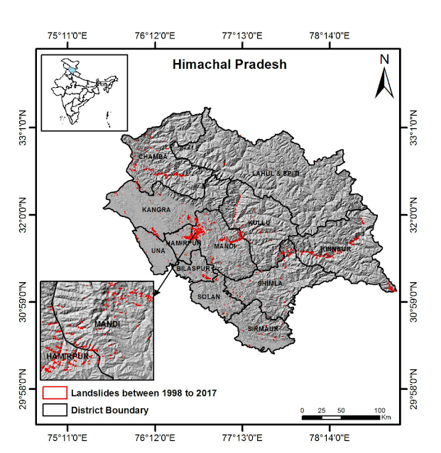
Himachal Pradesh is India's one of the most landslide-prone states. A staggering 17,102 landslides have been recorded in the state, underscoring the urgent need for effective early warning systems.

According to Dr Harish Bahuguna, Deputy
Director General of the Geological Survey of India (GSI), Himachal faces a 26%
high susceptibility to landslides. This alarming figure is part of a larger
national picture, with India recording a total of 87,230 landslides.
Furthermore, a concerning 25% of these landslides across the country are
reactivated, highlighting the persistent nature of this hazard.
Himachal's
Most Vulnerable Districts
A GSI Landslide Susceptibility Mapping of
India pinpoints Chamba and Kinnaur as the most vulnerable districts in
Himachal, with susceptibility rates of 42.86% and 39.93% respectively. Other
districts facing significant risk include:
- Kullu (24.30%)
- Lahaul-Spiti (22.32%)
- Kangra (21.88%)
- Sirmaur (17.22%)
- Shimla (14.95%)
- Mandi
These districts, covering a combined area of
42,093 square kilometers, are in dire need of targeted landslide prevention and
mitigation strategies.
What is a Landslide?
A landslide is a geological phenomenon that
occurs when a large mass of soil, rock, or debris moves downhill under the
influence of gravity. This movement can be slow and gradual or rapid and
catastrophic, causing significant damage to property and loss of life.
Characteristics
of Landslide Prone Areas
Himachal Pradesh, with its mountainous
terrain, steep slopes, and heavy rainfall, is highly susceptible to landslides.
Key characteristics of landslide-prone areas in the state include:
- Steep slopes: The
hilly topography of the region creates unstable slopes.
- Weak geological formations: The
presence of loose soil, weathered rocks, and fault lines increases
vulnerability.
- Heavy rainfall:
Intense precipitation triggers landslides by saturating the soil and
reducing its stability.
- Deforestation:
Removal of vegetation leads to soil erosion and loss of anchoring roots.
- Human activities:
Construction, road cutting, and improper land use can destabilize slopes.
Causes of Landslides
Landslides can be triggered by both natural
and human-induced factors.
Natural Causes
- Rainfall: Heavy and prolonged rainfall is the most
common trigger, saturating the soil and increasing its weight.
- Earthquakes:
Seismic activity can destabilize slopes and induce landslides.
- Slope angle and geology: Steep
slopes and weak geological formations are inherent risk factors.
- Vegetation: Lack
of vegetation reduces soil cohesion and increases erosion.
Anthropogenic Causes
- Deforestation:
Removal of trees and vegetation leads to soil erosion and instability.
- Construction activities:
Cutting into slopes for roads, buildings, or dams can disrupt the natural
balance.
- Mining and quarrying: These
activities weaken the rock structure and increase landslide risk.
- Improper irrigation:
Excessive irrigation can saturate the soil and trigger landslides.
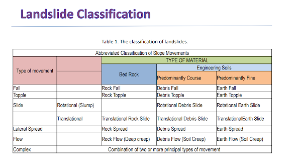
Types of Landslides
Landslides are classified based on the type
of movement and the material involved.
Types of Movement
·
Falls: This involves the free fall of rocks or debris from a
steep cliff or slope. The material typically breaks away due to weathering,
erosion, or undercutting.
- Example: Rocks
falling from a mountainside.
·
Topples: In this case, a block of rock or debris tilts forward
and overturns at its base. This often occurs on steep slopes with weak
underlying layers.
- Example: A large
rock mass rotating and falling forward.
·
Slides: This type of landslide involves the downward movement
of a mass of soil or rock along a defined slip surface.
- Rotational
slide:
The moving mass rotates backward as it slides, creating a curved slip
surface.
- Translational
slide:
The moving mass slides along a relatively flat surface.
- Example: A large
chunk of soil or rock sliding downhill.
·
Flows: These landslides involve the movement of material in
a fluid or semi-fluid state.
- Debris
flow:
A rapid movement of a mixture of water, soil, rocks, and organic matter.
- Earth
flow:
A slower-moving flow of mostly soil and water.
- Mudflow: A very
fluid flow of fine-grained material and water.
- Example: A thick,
muddy stream flowing downhill.
·
Creep: This is a very slow, gradual movement of soil or rock
downhill. It's often imperceptible except over long periods.
- Example: Tilting of
fence posts or cracks in walls due to gradual soil movement.
Impacts of Landslides
Landslides in Himachal Pradesh have severe
consequences:
- Loss of life and property:
Landslides can cause fatalities, injuries, and destruction of homes,
infrastructure, and agricultural land.
- Economic losses:
Disruption of transportation, communication, and economic activities.
- Environmental degradation: Soil
erosion, pollution of water bodies, and habitat loss.
- Disaster relief burden:
Landslides require significant resources for rescue, rehabilitation, and
reconstruction.
Case Studies of Landslides in
Himachal Pradesh
Let's delve into some specific case studies to
understand the devastating impact of landslides in Himachal Pradesh:
The 2023 Monsoon Devastation
The monsoon season
of 2023 brought unprecedented devastation to Himachal Pradesh, with landslides
being a major culprit. Several districts, including Shimla, Kullu, and Mandi,
witnessed catastrophic landslides that claimed numerous lives, destroyed infrastructure,
and disrupted livelihoods.
- Shimla: The state
capital bore the brunt of the landslides, with several buildings
collapsing and roads being blocked. The Summer Hill area was particularly
affected, highlighting the vulnerability of urban areas to these hazards.
- Kullu
and Mandi:
These districts, known for their tourist attractions, experienced
landslides that disrupted transportation, leading to stranded tourists and
economic losses.
Challenges
in Mitigation
While the
government has implemented various measures, addressing the landslide problem
in Himachal Pradesh remains a complex challenge due to:
- Geographical
Constraints: The mountainous terrain makes it difficult to
implement large-scale engineering solutions.
- Economic
Limitations: Limited resources can hinder the development and
maintenance of early warning systems and infrastructure.
- Climate
Change:
Increasing frequency and intensity of rainfall due to climate change
exacerbate the landslide risk.
- Population
Pressure:
Growing population and unplanned urbanization contribute to land use
changes that increase vulnerability.
Way Forward
To effectively
tackle the landslide menace, a multi-pronged approach is essential:
- Strengthening
Early Warning Systems: Investing in advanced technology for
real-time monitoring of rainfall, soil moisture, and seismic activity.
- Community-Based
Disaster Management: Empowering local communities through
training and awareness programs to enhance preparedness.
- Sustainable
Land Use Planning: Implementing strict regulations to
prevent construction in high-risk areas and promoting sustainable land use
practices.
- Infrastructure
Resilience:
Designing infrastructure, such as roads and bridges, to withstand
landslide impacts.
- Research
and Development: Supporting research on landslide mechanisms and
developing innovative mitigation technologies.
- Reforestation:
Promote afforestation and conservation of existing forests.
- Engineering measures:
Construct retaining walls, drainage systems, and slope stabilization
structures.
- Disaster preparedness:
Develop comprehensive disaster management plans, including evacuation
procedures and relief efforts.
By adopting these measures and fostering
collaboration between government, communities, and experts, Himachal Pradesh
can significantly reduce its vulnerability to landslides and build resilience.
The
Role of Technology in Landslide Management
Technology has
emerged as a powerful tool in the fight against landslides. By providing
real-time data, early warning systems, and advanced analysis capabilities, it
has significantly enhanced our ability to predict, monitor, and respond to
these natural hazards.
Early Warning
Systems
- Rainfall
Monitoring:
Real-time data on rainfall intensity and duration is crucial for
predicting landslide triggers.
- Soil
Moisture Sensors: Monitoring soil moisture levels helps in
assessing slope stability.
- Seismic
Sensors:
Detecting early signs of slope instability through seismic activity.
Remote Sensing
Technologies
- Satellite
Imagery:
Provides large-scale monitoring of landslide-prone areas, enabling
identification of potential hazards and tracking changes in land cover.
- Unmanned
Aerial Vehicles (UAVs): Offer high-resolution images for
detailed mapping and assessment of landslide-affected areas.
- LiDAR
(Light Detection and Ranging): Creates precise 3D models of the
terrain, aiding in identifying areas of instability and monitoring slope
deformation.
Geographic
Information Systems (GIS)
- Data
Integration: Combines various data sources (topographic,
geological, land use, etc.) to create comprehensive landslide
susceptibility maps.
- Risk
Assessment:
Helps in evaluating the potential impact of landslides on infrastructure
and population.
- Emergency
Response:
Supports efficient planning and coordination of rescue and relief efforts.
Early Warning
and Communication Systems
- Mobile
Applications: Disseminating early warnings to the public
through mobile devices.
- Public
Address Systems: Providing timely alerts to communities at risk.
- Social Media: Leveraging social media platforms for rapid information dissemination and crowd-sourcing data.
Challenges and
Opportunities
While technology offers immense potential,
challenges such as cost, accessibility, and digital literacy need to be
addressed. Additionally, continuous research and development are essential to
improve the accuracy and effectiveness of these technologies.
By investing in
technology and building robust early warning systems, Himachal Pradesh can
significantly reduce the loss of life and property caused by landslides.


Post a Comment